Explore Mars with JMARS
Temperature and Thermal Inertia Maps
Explore how different surfaces heat and cool across Mars.
Temperature Charts
Scientists can derive temperatures from infrared measurements and use thermal models to compute daily and annual temperature charts
1. Open JMars
2. Zoom in to location(s) of interest.
3. Click on "Layers"; under "Search," type in KRC. Choose "Temperature Calculator".
4. Close the "add new layer" window if it stays open.
4. Click on location of interest. Change name if desired. Choose "add" in pop up.
5. Repeat step 4 for all locations of interest.
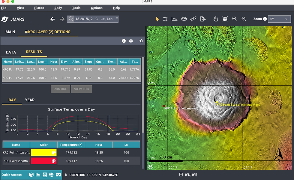
6. Double click on "KRC layer".
7. Choose "Results" tab.
8. Select all rows with locations you want graphed. e.g. hold shift click.
9. Click: "run KRC for necessary data point(s)." Wait ~10-20 seconds. Note: created graph has two tabs: Day and Year.
10. Options: Change variables like the time of day, albedo, and/or slope to see what effects it has. For more options see video1 or video2. (Changing the time of day effects only the year chart.)
*KRC is a computer program designed to compute surface temperatures for planets and satellites with or without modest atmospheres. The acronym KRC is simply K for conductivity, R for “rho” (ρ) for density, and C for specific heat—the three physical properties used to calculate thermal inertia. Reference
A comparison of daily temperatures at the summit and base of Olympus Mons using KRC data reveals intriguing patterns. Key questions to consider:
-
Why is the base warmer than the summit?
-
What causes the sharp slope in the temperature data at the summit?
-
Why does the temperature remain constant throughout the night?
These observations invite exploration of properties such as atmospheric density, surface materials, and heat retention at different elevations as well as specific thermodynamic conditions like the triple point of CO₂, influence the system.
Thermal Inertia Map
Thermal inertia refers to a material's ability to conduct and store heat. In planetary science, it measures the subsurface's capacity to absorb heat during the day and retain heat after sunset and cool during the night. Factors influencing thermal inertia include bulk density, particle size, and the degree of cementation. Learn more: HiRISE: ESP_039485_1660.
-
Open JMARS
-
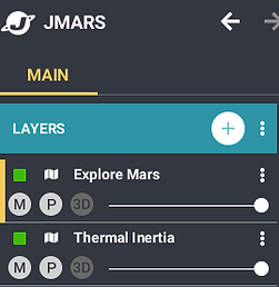
Make the "Explore Mars" Layer the top layer and move the "Thermal Inertia" layer under it. See screen shot on theright.
-
Move the slider back and forth in the "Explore Mars" layer to change the layer transparency.
-
Zoom in as desired.
-
Observe differences and ask questions.
-
See the next page to make day and yearly profiles of any location on Mars!
-
You may want to google what variables affect thermal inertia on Mars to give you more insight.